
SHENZHEN, China, May 13, 2025 /PRNewswire/ — As wildfires intensify across the U.S., the urgency to respond faster and more effectively is rising. In Ventura County, California, where extreme weather and low humidity have turned wildfire season into a year-round battle, firefighters are facing larger, faster-moving blazes than ever before.

Ventura County Firefighters Are Transforming Wildfire Response with DJI Drones
To meet this challenge, the Ventura County Fire Department (VCFD) is turning to drone technology to gain an edge – not just during active fires, but across every stage of the firefighting mission. “Drones have become a force multiplier in the fire service,” said Sean Ameche, Fire Captain of the Ventura County Fire Department.
Beyond the Blaze: Drones in the Mop-Up Phase
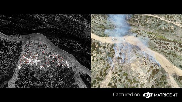
While drone technology plays a growing role in active fire response, its impact doesn’t end when the flames are contained. In Ventura County, they’ve become indispensable in the next and equally critical stage: mop-up. This involves locating and extinguishing lingering hotspots that could reignite if left unchecked.
Traditionally, the mop-up phase has been a slow, labor-intensive process, requiring firefighters to walk large areas of scorched terrain for days. Now, with aerial thermal imaging and automated mapping, the VCFD can do the same work faster, safer, and with far greater precision.
Using the DJI Matrice 4T, the VCFD has transformed how it approaches post-fire operations. The drone’s stable performance in high winds, paired with thermal and zoom cameras, allows crews to detect even the smallest heat signatures – sometimes as small as a cigarette butt – and guide ground teams directly to those locations. Meanwhile, its laser rangefinder ensures accurate positioning, while its ability to operate day or night delivers real-time aerial insights whenever needed. “Drones have provided us an invaluable tool with firefighting around the clock. It allows us to look at things through the night-time hours where we previously would not have manned aircraft,” said Jimmy Hidalgo, Fire Captain of Ventura County Fire Department.
From Planning to Action
For the VCFD, mop-up is a structured, three-phase process: mission planning, data collection, and analysis.
It begins with defining a mapping area based on the fire’s perimeter and terrain. From there, the drone executes an automated flight path to collect both visual and thermal imagery. Once the data is collected, it’s processed using tools like Nova Maps to produce stitched aerial visuals and real-time hotspot analysis.
This process gives both command staff and field crews a unified picture of where to focus their efforts, helping to confirm that containment lines are holding – and that the fire is truly out.
Nick Cleary, the Division Chief of the Ventura County Fire Department, said that: “It’s a game changer. Years ago, we were working off paper maps, and now, on your mobile device, at your fingertips, you have real-time information.”
Real-Time Mapping, Real-World Impact
During the Kenneth Fire earlier this year, the VCFD used drones to map the fire perimeter and locate residual hotspots near homes. The drones allowed safe, stable flight over uneven terrain, even in winds exceeding 30 miles per hour, guiding firefighters directly to remaining threats.
Post-mission, the thermal and visual images were processed into georeferenced maps, giving teams a reliable view of the fire’s status as the situation evolved.
Beyond Wildfires: Versatility in the Field
Drones are also proving useful in emergencies beyond wildland fires. During a night-time HAZMAT incident, the VCFD used the DJI Mavic 3T‘s zoom camera and spotlight to assess the scene before deploying an entry team.
This aerial reconnaissance helped responders to assess the amount and type of material on site and identify potential hazards, without putting personnel at unnecessary risk.
Looking Ahead: The Next Chapter in Aerial Response
Recently, the Ventura County Fire Department logged more than 320 miles of drone flight during a single month of wildfire operations – a reflection of how integral drones have become to modern firefighting. As adoption continues to grow, the department is also exploring new capabilities like Virtual Cockpit and testing Drone as First Responder (DFR) technology to provide even faster support across a broader range of emergencies.
Whether it’s containing an active blaze, securing an area during mop-up, or safely assessing hazardous sites, drones are helping the VCFD work faster, stay safer, and act with greater confidence. “We’re not only fighting fires differently, we’re seeing them differently.” Fire Captain Sean Ameche said.
At DJI, we’re proud to support the firefighters and emergency teams leading the way, in Ventura County and beyond.